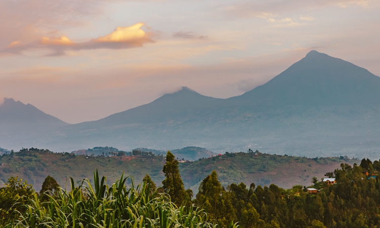
Virunga Conservation Area – The Virunga Conservation Area is home to the Virunga, a chain of volcanoes shared by the Democratic Republic of Congo, Uganda, and Rwanda.
The Virunga chain consists of eight volcanoes, including two active ones, Mt. Nyiragongo and Mt. Nyamuragira.
The name “Virunga” comes from a local word, “ibirunga,” which means “volcano.” The Virunga Mountains lie between the shores of Lake Kivu, Lake Edward, and the western branch of the large East African Rift Valley.
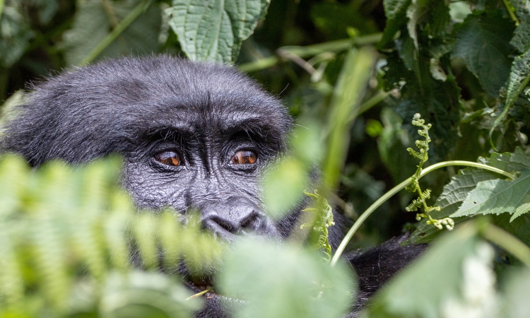
The slopes of the mountains are home to one of the last remaining populations of mountain gorillas.
In addition to mountain gorillas, the Conservation Area is home to a variety of other wildlife, including forest elephants, leopards, bushbuck, giant forest genets, bush pigs, as well as deer and antelopes.
Other primate species include golden, black and white colobus, red colobus, De Brazza’s monkeys, and bush babies.
The earliest inhabitants of the Conservation Area were the Batwa, also known as pygmies.
They adapted to living in these ancient forests and relied on them for shelter, sustenance, and medicinal purposes.
Visiting the forest inhabitants while in the area is an unforgettable experience.
The Conservation Area is also home to four national parks: Mount Rwenzori National Park and Virunga National Park in the Congolese part of the area, and Mgahinga Gorilla National Park in Uganda.
You can trek gorillas in three of these parks. Congolese safaris are also available in Virunga, with Volcanoes National Park in Rwanda offering gorilla trekking tours.

The following is a list of the eight volcanic mountains in the Virunga Conservation Area, which are located in three different countries:
Mount Nyamuragira
Nyamuragira, like Hawaii’s Mauna Loa, is one of the world’s most active volcanoes. It’s located in the central African nation of the Democratic Republic of Congo, at an elevation of 3,058 meters above sea level.
The volcano has a caldera that is 2 kilometers wide and 100 meters high at the summit.
The volcano has erupted at least 40 times since the year 1885, with the most recent being in 2011.
Mount Sabyinyo
Sabyinyo Mountain is one of the oldest volcanoes in the world. It is situated on the border of three countries: Rwanda, Uganda, and the Democratic Republic of Congo.
The name “Sabyinyo” is derived from a local word that means “worn out teeth.”
The mountain offers an opportunity to be in three countries at one point, but it can only be summited from the Uganda side due to the rugged nature of the Rwanda and Congo sides.
Hikes start from Mgahinga Gorilla National Park.
Mount Bisoke
Mount Bisoke is situated on the border of Rwanda and the Democratic Republic of Congo. It is at an altitude of 3,711 meters.
The highest point of the mountain is located in Rwanda and is surrounded by a crater lake. The mountain also has another crater lake called Lake Ngezi, which is 11 kilometers from the summit crater.
The name “Bisoke” comes from a local word meaning “soaked with water” because the summit of the mountain is always filled with fog.
Mount Gahinga
Gahinga is a mountain located on the border between Uganda and Rwanda. It is situated between Mount Sabyinyo and Mount Muhabura.
The name Gahinga comes from a local word meaning “pile of stones.” The mountain got its name from the small piles of stones found in the farmlands of the area.
Gahinga is located at an altitude of 3,474 meters above sea level. The mountain has a beautiful swampy caldera on the summit.
Mount Nyiragongo
Nyiragongo is one of the most active volcanoes of the Virunga range, along with Mount Nyamuragira.
Mount Nyiragongo rises to an altitude of 3,470 meters and is known for its destructive eruptions.
The volcano’s lava lake moves at a speed of 97 kilometers per hour.
The most recent eruption occurred in 2002 when the lava flowed into the streets of Goma town and into Lake Kivu, destroying many properties within Goma.
The entire day was consumed by the eruption.
Mount Mikeno
Mikeno Mountain is the second highest peak of the Mount Virunga Massif, standing at 4,437 meters above sea level and is located in the territory of the Democratic Republic of Congo, close to the border with Rwanda.
The name “Mikeno” is derived from the local word meaning “poor.”
The rugged slopes of the mountain make it difficult for human habitation. Mount Mikeno is also the steepest peak of all the volcanoes in Virunga.
Climbing Mount Mikeno requires experienced and technical hikers.
Mount Karisimbi
Karisimbi is one of the highest volcanoes in Virunga, standing at 4,507 meters above sea level.
The name comes from a local word meaning “white shell,” referring to its snow-capped summit. The lavas of the mountain date back to between 0.24 and 0.010 million years ago, suggesting that the volcano is very young.
The hike takes two days and starts from the Volcanoes National Park in Rwanda.
Mount Muhabura
Also known as Mount Muhavura, this mountain is located on the border between Rwanda and Uganda.
It is the third highest mountain in the Virunga Volcanoes, standing at an altitude of 4,127 meters.
The mountain is visible from many parts of Uganda and Rwanda because of its steep slopes.
The name “Muhabura” comes from a local word meaning “guide,” referring to the traditional use of the mountain to facilitate navigation.
The Virunga Conservation Area is home to the Virunga chain of volcanoes, including two active ones, and is known for its diverse wildlife, including mountain gorillas.
The area is shared by the Democratic Republic of Congo, Uganda, and Rwanda, and offers opportunities for gorilla trekking and safaris.
So as you plan your next holiday, let the Virunga Conservation Area be your next destination.